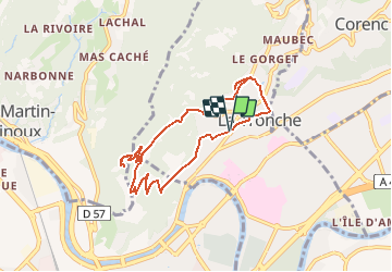
![](/images/other/stat-length.png)
![Randonnée Marche La Tronche - Mont Jalla - Photo](https://media.geolcdn.com/t/1900/400/ext.pjpeg?maxdim=2&url=https%3A%2F%2Fstatic1.geolcdn.com%2Fsiteimages%2Fupload%2Ffiles%2F1553511878bg_sport_marche.png)
Mont Jalla
ranchoup
Utilisateur
![Longueur](/images/other/stat-length.png)
![Altitude max](https://static1.geolcdn.com/siteimages/upload/files/1508320355ic_sort_altitude_max_24dp.png)
![Dénivelé positif](https://static1.geolcdn.com/siteimages/upload/files/1508320355ic_sort_den_pos_24dp.png)
![Km-Effort](/images/other/stat-length.png)
![Altitude min](https://static1.geolcdn.com/siteimages/upload/files/1508320355ic_sort_altitude_min_24dp.png)
![Dénivelé négatif](https://static1.geolcdn.com/siteimages/upload/files/1508320355ic_sort_den_neg_24dp.png)
![Boucle](https://static1.geolcdn.com/siteimages/upload/files/16400158638029165_repeat_loop_refresh_sync_direction_icon.png)
![Marche](https://static1.geolcdn.com/sitytour/trail-icons/101.png)
2h56
Difficulté : Facile
![Scannez ce code QR pour ouvrir la randonnée dans l'application SityTrail](https://capi.geolives.com/qq0zvz2zws4bq2lad0pu/sitytour/trails/2561890/qr.png?size=200)
Application GPS de randonnée GRATUITE
À propos
Randonnée Marche de 8,1 km à découvrir à Auvergne-Rhône-Alpes, Isère, La Tronche. Cette randonnée est proposée par ranchoup.
Description
Boucle à faire pour un plan B, mais très fréquentée par les joggeurs le we.
Chemin un peu trop raide sur le tronçon Bec de Corbeau-Noyarey. (et pourtant c'est un tronçon GR).
Faire le petit crochet jusqu'à la petite chapelle de la Vierge Noire (située à coté d'une maison au lieut-dit la Pinotte.
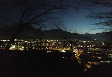
Beaux points de vue sur Grenoble et Belledonne.
Localisation
Commentaires
Randonnées à proximité
![Randonnée Marche Corenc - Mont Saint-Eynard par le Pas Guiguet - Photo](https://media.geolcdn.com/t/375/260/f1d9b7f1-9f84-43fa-9ff3-d6f6d9ae7425.jpg&format=jpg&maxdim=2)
![Marche Marche](https://static1.geolcdn.com/sitytour/trail-icons/101.png)
Marche
![](/images/other/stat-length.png)
![](https://static1.geolcdn.com/siteimages/upload/files/16400158638029165_repeat_loop_refresh_sync_direction_icon.png)
![Randonnée Marche Fontaine - M le 20 cabane de Laura - Photo](https://media.geolcdn.com/t/375/260/40be2dc6-e0ec-4dac-a44e-b55a1a5b0b08.jpg&format=jpg&maxdim=2)
![Marche Marche](https://static1.geolcdn.com/sitytour/trail-icons/101.png)
Marche
![](/images/other/stat-length.png)
![](https://static1.geolcdn.com/siteimages/upload/files/16400158638029165_repeat_loop_refresh_sync_direction_icon.png)
![Randonnée Course à pied Seyssinet-Pariset - 19 mai - Photo](https://media.geolcdn.com/t/375/260/ext.jpg?maxdim=2&url=https%3A%2F%2Fservices.sitytrail.com%2FGeolivesWS%2FDownloadMedia.ashx%3FTrailID%3D128561%26Media%3D20120519101643.jpg)
![Course à pied Course à pied](https://static1.geolcdn.com/sitytour/trail-icons/103.png)
Course à pied
![](/images/other/stat-length.png)
![](https://static1.geolcdn.com/siteimages/upload/files/16400158638029165_repeat_loop_refresh_sync_direction_icon.png)
![Randonnée V.T.T. Grenoble - Grande Traversée des PréAlpes à VTT : Grenoble - Sisteron - Digne les Bains - Photo](https://media.geolcdn.com/t/375/260/ext.jpg?maxdim=2&url=https%3A%2F%2Fservices.sitytrail.com%2FGeolivesWS%2FDownloadMedia.ashx%3FTrailID%3D102152%26Media%3D2542_2.jpg)
![V.T.T. V.T.T.](https://static1.geolcdn.com/sitytour/trail-icons/202.png)
V.T.T.
![](/images/other/stat-length.png)
![](https://static1.geolcdn.com/siteimages/upload/files/16400158638029165_repeat_loop_refresh_sync_direction_icon.png)
![Randonnée A pied Gières - De Gières au col du Gourlu - Photo](https://media.geolcdn.com/t/375/260/b782ea79-2f14-452c-9af6-76dad2fec664.jpeg&format=jpg&maxdim=2)
![A pied A pied](https://static1.geolcdn.com/sitytour/trail-icons/100.png)
A pied
![](/images/other/stat-length.png)
![](https://static1.geolcdn.com/siteimages/upload/files/16400158638029165_repeat_loop_refresh_sync_direction_icon.png)
![Randonnée A pied La Tronche - Grande Traverse de Meylan - Photo](https://media.geolcdn.com/t/375/260/07dafc4a-0388-404d-b349-5b51404ed80b.jpeg&format=jpg&maxdim=2)
![A pied A pied](https://static1.geolcdn.com/sitytour/trail-icons/100.png)
A pied
![](/images/other/stat-length.png)
![](https://static1.geolcdn.com/siteimages/upload/files/16400158638029165_repeat_loop_refresh_sync_direction_icon.png)
![Randonnée V.T.T. La Tronche - bastille vtt - Photo](https://media.geolcdn.com/t/375/260/ext.jpg?maxdim=2&url=https%3A%2F%2Fstatic1.geolcdn.com%2Fsiteimages%2Fupload%2Ffiles%2F1524743154velo.jpg)
![V.T.T. V.T.T.](https://static1.geolcdn.com/sitytour/trail-icons/202.png)
V.T.T.
![](/images/other/stat-length.png)
![](https://static1.geolcdn.com/siteimages/upload/files/16400158638029165_repeat_loop_refresh_sync_direction_icon.png)
![Randonnée Marche Fontaine - Le Moucherotte par le parking sous le tremplin de Saint-Nizier - Photo](https://media.geolcdn.com/t/375/260/c12500b5-9735-4a71-9b4c-b5c3fdd7de5b.jpg&format=jpg&maxdim=2)
![Marche Marche](https://static1.geolcdn.com/sitytour/trail-icons/101.png)
Marche
![](/images/other/stat-length.png)
![](https://static1.geolcdn.com/siteimages/upload/files/16400158638029165_repeat_loop_refresh_sync_direction_icon.png)
![Randonnée Marche Fontaine - Pariset - Ferme de Charvet - Parking sous le tremplin - Sous le Moucherotte - Photo](https://media.geolcdn.com/t/375/260/5bb92c8c-4697-4d2b-afbb-10561dcb69b6.jpg&format=jpg&maxdim=2)
![Marche Marche](https://static1.geolcdn.com/sitytour/trail-icons/101.png)
Marche
![](/images/other/stat-length.png)
![](https://static1.geolcdn.com/siteimages/upload/files/16400158638029165_repeat_loop_refresh_sync_direction_icon.png)